For this trip, I intended to start at my usual spot on the Eastern shore and make it to Seletar airport in the north, then turn around and come back along Bukit Timah, circling all the major water catchment areas.
ECPark to Seletar
Started at the Siglap connector at East Coast Park at 4.25 pm Saturday. The route up the connector to Kembangan was the usual (see previous blog post). Took the opportunity to pump my tires for free at the Shell petrol station on Changi Road near the end of the first stretch of the connector. The connector continues behind Kembangan MRT. Having used this connector several times, I have learnt several short cuts to get off it and onto other roads: I like to turn into the housing estate in Jalan Daud, just before the PIE, and go all the way down the road to a seemingly dead end; but look at the right corner and you will find a small exit ramp that's leads you to the pedestrian crossing at Eunos Link.
Up along Eunos link, I turned left into Bartley Road and then right up along Upper Paya Lebar Road. This last road is not my favourite for cycling because of massive traffic and very narrow sidewalks (yeah, yeah, pedestrian sidewalks are not lawfully meant for cyclists, but since road vehicles don't give cyclists much space here, safety reasons in some situations strongly suggest the sidewalks; just look out for the odd walker---outside city/town centres hardly anyone walks around much).
[Note 1: One side of every road typically has much broader sidewalks than the other side, so choose wisely. UPLebar Road is undergoing some widening of its sidewalks. ]
[Note 2: Follow Law. Don't cycle on pedestrian sidewalks. Hmmm...]
From there it was onto Boundary Road and then into Lorong Chuan --- first time there, although I had heard about it. Nice vibes. Next turn was into Serangoon Gardens. Had not been there in decades. It was nice to see the roundabout, which I remember, still there.
From Serangoon Gardens I headed North, cut through the Ang Mo Kio Industrial estate, and found Seletar Hills. As I mentioned in an earlier post, Ang Mo Kio didn't exist when I was growing up. It was all forested area, as was much of both sides of Yio Chu Kang Road (and most of Nee Soon, Sembawang, Ponggol...)
Got slightly lost in the western end of Seletar Estate which I was not familiar with. Just as I found Seletar Road and turned, I saw a car driven by a personality which I recognised: a former (retired) cabinet minister. Am 99% sure it was him.
Jalan Kayu to Yishun
Now for a shock (although I had heard about it): My childhood Jalan Kayu road has been deformed. It no longer has an entrance from Yio Chu Kang Road (and the corner post office-converted -to-child-care-centre is gone . see earlier post). A new wide road called Sengkang Road West has been created (or maybe extended from its previous version) that leads you efficiently to Seletar Aerospace.
The part of Sengkang Road West beyond Sengkang Road Avenue was not yet opened for traffic but the barriers were not meant for cyclists I guess. So here are some preview photos:
 |
| Sengkang Road West (to be opened) |

Following the construction workers, I found openings that led to me out of the new-but-not-yet-open road to the old Seletar Camp area with its picturesque black and white bungalows and very British street names: Regent street, Picadilly circus etc. which triggered memories of the British version of Monopoly.
Finally, here the rain caught up with me. So I decided it was prudent to take shelter at a bus stop. Here is a photo opposite that stop:

Only one bus comes here: SBS 103. I am glad it is still running almost the same route as four decades ago !! I think that is remarkable considering how fast, and how much, things change on this island.
Although I wanted to explore the quaint parts of old Selatar Camp, it would have meant a big detour (according to the online map) from the connector that would lead me to Yishun where I intended to have a dinner break. Grabbing the pause in the rain, I made a run for it, stopping to take pictures of Seletar Airport:

Many big names have come to the newly developed Seletar Aero-space. I noticed Rolls Royce and Bell helicopter among others.
An eye-opener was discovering the dam across the mouth of some former river while crossing from Seletar to Yishun: The map informs me that this is now the Lower Seletar Reservoir. The side facing the Johor straits had essentially turned into mudflats and I saw people out there looking for whatever it is that lives in those conditions (I guess they must be some edible seafood.).
 |
| From road above dam forming Lower Seletar Reservoir, facing JB |
For the young ones: It was all Nee Soon decades ago before the re-naming zeal. Now some parts are Yishun (the han-yu-pinyin-ised version) while, amusingly, they have kept the Nee Soon name at other places (maybe to honour the pioneer of that name).
Rain was re-appearing and anyway I needed a dinner break. Could not see any food place as I was moving along Yishun Avenue 1. Stopped to ask two workers: "Go straight and turn right"they said. Did that and still could not see anything except brand new HDB blocks. Asked another guy: "Go through this carpark and there is a coffee shop near the exit". Did that and still nothing but tall buildings and no food. Asked third guy: "Oh, its just behind this building across the road. Did that and found it: Yishun Mall.
Timing was perfect. It was cats and dogs as I parked my bike. This mall was not the typical concrete building with AC and the usual standard shops. It was rather the name given to a congregation of open air coffee-shops, and two-storey shop-houses, with your usual NTUC around the corner.
Found food at one of the places and took my time while waiting for the rain to stop. Then suddenly remembered it was Lunar Eclipse night (and supposedly Blood Moon!), but I was in the middle of dinner at 8pm when it was supposed to happen!...consoled myself that the skies were probably cloudy and it wouldn't be visible (was I right?)
[Suggestion to HDB Town Planning Committee: For the benefit of random tourists and night cyclists' who do not own a smart phone (or haven't figured out all it can do, like indicate nearby eating places when you zoom in on an online map): All town centres should have clearly marked signs at major intersections/entrances pointing to nearest makan places. ]
Yishun to Woodlands
While having dinner I pondered whether to go south immediately along Mandai Avenue/Road or to go North around Chong Pang Camp and then head south. I decided on the latter option as I wasn't sure if Mandai Road was cycle-friendly, especially on a dark and wet night. Also I thought it would be cool to loop around all the water catchment areas rather than cut through them!
So I went along Yishun Ave 11 and then up along Yishun Central, discovered Yishun Cental (Northpoint Mall etc), and continued along Yishun Avenue 5. But I was feeling slightly drowsy. I felt like taking a short nap somewhere. Looked around to see where. Noticed the Sri Narayana Mission Home. Gate was open and the security guy was sitting some distance away. Thought of going in, chatting with him and asking if I could catch a catnap in some corner. But I didn't. He probably would have thought I was some weirdo. Then I passed the Yishun Christian Church. Gate was open, and the same thought flashed through my head. But again I thought they would think I was a weirdo.
Immediately after that I saw the solution: a comfortable looking void deck with chairs. Turned out it was just outside some RC and some "uncles" were playing Chinese chess on tables marked with the board. I didn't use their chairs but sat on a concrete seat in the "public domain", which unfortunately had a divider in the middle to make it uncomfortable for anyone to lie down. Never mind, I could sit in peace. Closed my eyes and used all the Yogic tricks I knew to calm myself and relax even if I couldn't doze off. Picture is below:

[Suggestion to HDB Void Deck Planning Committee: For the benefit of people locked out of their homes and night cyclists' looking for rest spots: Benches should be long enough to lie down on, without annoying dividers that hurt the back. ]
After 15 minutes of recharging I set off again, hit the boundary of Chong Pang Camp and went North along Sembawang Road, then Gembas Avenue looking for Woodlands Avenue 7. The whole stretch was very quiet and sparsely populated. But the main problem was I was getting tired again. I decided I better take regular short breaks, so looked for my next cat-nap spot. Decided to try my luck at an inviting void deck along Woodlands Ave 7 which had concrete seats. But the seats were narrower and less comfortable than at Chong Pang. Unexpectedly, I found some chairs nearby. Maybe they were set up for someone to play mah-jong. But no one was around, so I decided to rest there (was not chased away). Picture:

Continued along Woodlands Ave 7. There was a cycling track under the MRT line, just as in Tampines town, but I found people walking on my track! (Ha! You walk on mine, I cycle on yours?!) In trying to connect to Woodlands Ave 3, I chanced upon the Civic Centre. Seemed a perfect place for a toilet break. Used the hand dryer there to dry my T-shirt and hair too (the drizzle and humidity had made conditions moist).

Onwards along Woodlands Ave 3 and onto Woodlands Road. By now I almost regretted taking this longer route rather than the Mandai option. Was tired and now I was in the middle of nowhere, passing Kranji MRT. But still, at least I saw some landmarks, such as the entrance to the Kranji War Memorial.
Along this very long, desolate, stretch of Woodlands Road, which eventually curved south and then south-east, I started taking breaks at bus-stops. My butt, neck and shoulders were aching. If anyone noticed someone doing Yoga stretches around midnight along Woodlands Road bus-stops on that day: It was me.
I also noted that no matter how isolated a stretch was, and how late it was, there would always be someone walking along the road or waiting for a bus or doing something.
Near Yew Tee MRT, while doing my Bus-Stop-Yoga (patent pending) I saw a strange character (stranger than me doing Yoga at a bus-stop) across the road. He was waving at cars, holding something shiny in one hand, with a bag in another hand. Couldn't tell what it was, but I guess he was trying to sell something. It seemed odd, because it was past midnight, very quiet, and in the middle of nowhere (or so it seemed to me). One taxi stopped when he waived but then continued. I continued too.
A stretch of Woodlands Road reminded me of Old Tampines Road: No sidewalks, and single lane (as I recall). So I had to take it. Road was slippery from the rain and sloping downhill. Had to keep pumping the brakes. Hoped that the occasional the bus drivers who passed me were not also watching videos while driving. Made it safely to a stretch with sidewalks.
Upper Bukit Timah and Dunearn Roads
Eventually "civilisation" re-appeared along Upper Bukit Timah Road. Needed to take another rest-break/ cat-nap or something more. Found a walking/cycling track running the length of a canal behind the "Linear" near Bukit Panjang LRT. Along it I came across a worker resting. He was lying on the ground, on his side, engrossed in his smartphone. Loved how he could just relax like that.
But the location didn't suit me. So I moved on along the path of the under-construction Downtown line.
Eventually I reached the Rail Mall which seemed promising. Most shops were closed and I found some comfy chairs outside one closed English school for kids. Sat me down to rest there although it was just two doors away from a still-open noisy pub.
After about 15 minutes I felt I should press on, but I made a wrong turn when attempting to exit the Mall and ended up finding a small park near its end.
(Saw a car parked there with lights blinking as I passed. I think a biology lesson was on going).
Finding that quiet deserted park changed my plans. I saw benches under a hut and thought that maybe I could get proper sleep there. Unfortunately the benches were not long enough and very cold, as they were made of concrete.
But there were longer wooden benches in the open, so I decided to risk the return of the rain and sleep on those. Although they were damp, I had come prepared with waterproof track pants and a jacket which I immediately unpacked and suited up.
It was so very comfortable to lie down flat on those benches and I got a much needed rest for my spine, and momentary bliss even though I didn't fall asleep. Clean fresh air and a full moon looking down on me. Picture:

[Note: the benches did not have annoying protrusions in the middle. I guess BT residents do not get many ``hobos" sleeping on their park benches.]
After about 30 minutes I felt ready to continue and as I left I noticed that the Mobile Biology Classroom had disappeared.
Made very good progress down the rest of Upper Bukit Timah Road which then became Dunearn Road.
Passed some well known landmarks and schools though I could not see much because of the darkness. Paused, when needed, to do Bus-Stop-Yoga.
Little India, Geylang and End.
Was expecting to find some open coffee shops in Little India but was very surprised by how deserted the place was. Eventually found someone supporting a lamp-post. He informed me that the only place where I could get a hot drink was at Mustafa's café down the road.
(Turns out he was not completely right. Near Mustafa I found one other open café and also an open ``dollar shop''. )
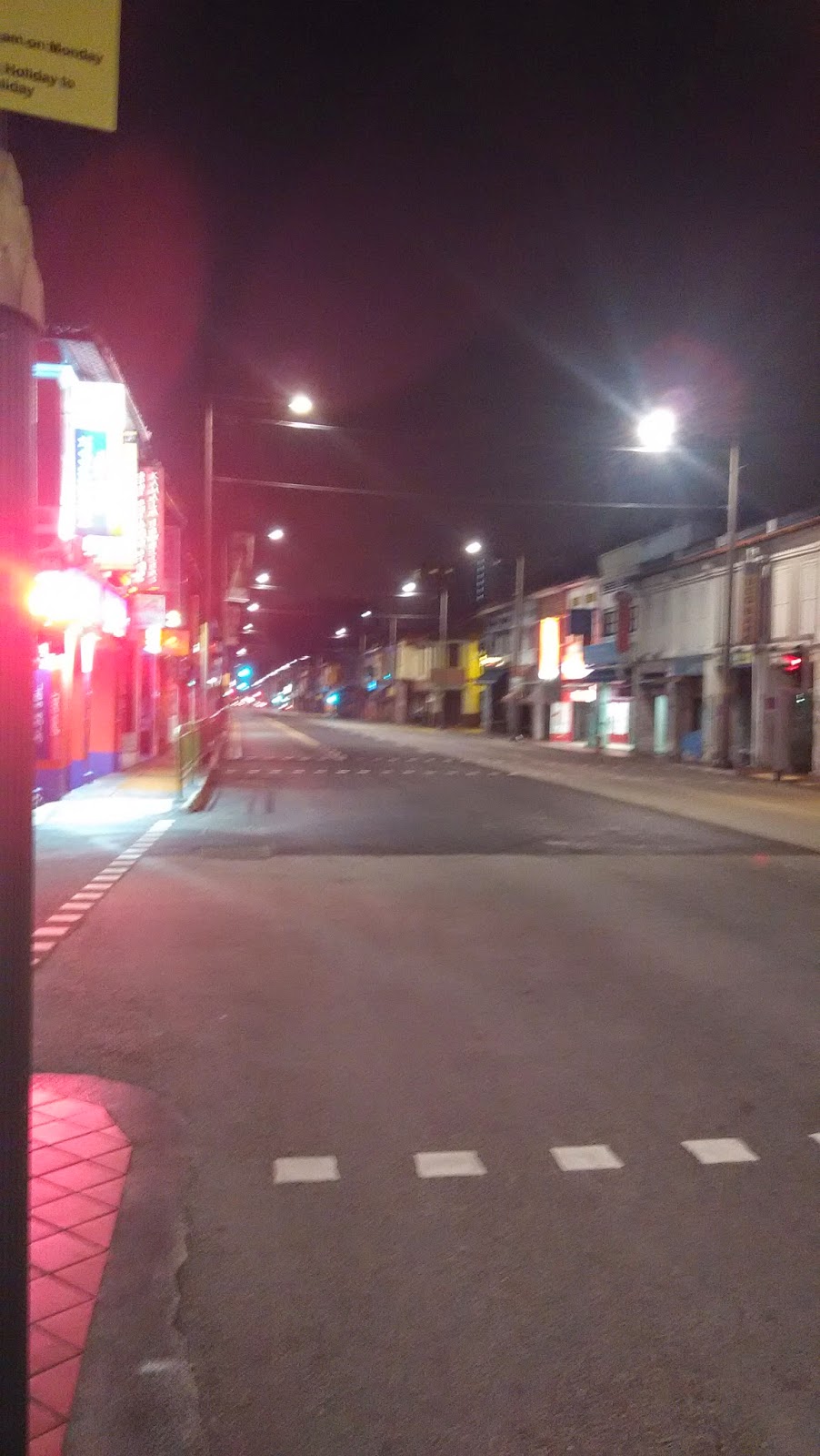 |
| Little India 3am Sunday 5th April 2015 |
Is it always this quiet, or is it due to the recent anti-liquor laws?
I was craving for a hot drink. Got a Milo and sat at 3am outside Mustafa to savour it. Quite a few people were there, doing shopping (it is open 24 hours!) or snacking.

The Arya Samaj building that I used to visit with my parents every Sunday as a kid is still there on Syed Alwi Road. My fondest memories of its are of the hot, freshly made "jelibis" they served with meals. (I didn't attend the services, just played with other kids and waited for the jelibis.)

As I had reached Little India much earlier than expected, I decided to head straight home from here rather than go through Tanjong Rhu and the East-Coast Park. Being familiar with the roads in the City area, having cycled or walked around here many times, I used various short-cuts to get home.
Went through Lavendar, Geylang, Old Airport Road, Dunman Road, Crescent Road, Mountbatten Road, Marine Parade Road. There was almost no traffic on the roads, so I could blaze through.
(Geylang had quite a few coffee shops and fruit stalls open even then. So anyone needing some exotic fruits at 4am can head there. Hey, I am talking of Durians, ok?)
Reached home at 4.25am.
A 12 hour overnight x-country cycling trip concluded. Estimated 120km covered.
 |
| My trusty 14 year old bike. Its a bit rusty now, has no suspension, and creaks, but still has good balance. |
Epilogue
During this trip I used or passed by a few roundabouts (a disappearing feature): Serangoon Gardens, Picadilly Circus, Newton, Marine Parade. Are there others in Singapore?
I have some Suggestions for the Sidewalk Planning Committee:
Sidewalks should be broad enough for two persons to walk side by side, or one (dismounted) cyclist pushing his bike.
Sidewalks that have sudden change of slope, or which end in steep steps (as near Sembawang Shopping Centre), should have clear markers, preferably in bright yellow (more visible at night).
A Suggestion on metal railings that mark the end of sidewalks which end abruptly before a drain: Not sure which Committee to refer this is, so maybe the newly formed Inter-Ministry-Coordinating (Complaints?) Agency (? the one formed after the fishball-stick incident) is relevant: Such railings should be painted bright yellow to be more easily visible at night.
 |
| Approximate cycling path indicated in black. The upper and western paths are close to the NE MRT line. |